 Day 2 of our EPIC "4 fourteener's in 3 days weekend". This is our first snow crossing on our way up to Redcloud Peak from the Silver Creek Trailhead where we camped. We woke up at 4:15am chowed down our bagels with cream cheese and reached the National Forest register around 5:00am. It was still very dark at this time so headlamps were essential. Being a little freaked out about bears, I made sure Toby had on his bell!
  The sun was just starting to hit the peaks opposite the drainage we were hiking up. It was a beautiful sunrise!
 Yes, I am a big dork.
 The last ascent up to Redcloud Peak. Not too bad, although it looks more like ski turns!
 Brian sitting at 14,034 feet signing us into the registry of Redcloud Peak! After signing our names he checked out the names of the folks that had peaked the day ahead of us. He discovered one of our friends from Gunnison, Mr. Evan Strauss and girlfriend had just hiked these two mountains 1 day ahead of us. CRAZY! we've never seen the names of anyone we knew on a registry before so that was really cool!
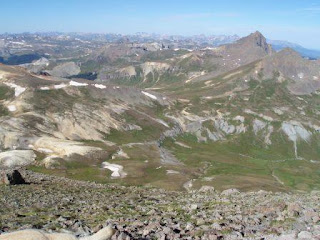
 We had gained 3,700 feet of elevation gain over a period of 4.5 miles. This is not where we stopped however, we were in for "bagging" as they say two fourteeners today! Toby, below, is looking over toward Sunshine Peak which is 1.5 miles South of us.
 Knowing we would be exposed above treeline for several hours we didn't stop for many pictures on the way over to Sunshine Peak. Redcloud is behind me to the right. We ate lunch on Sunshine at oh, 14,001 feet! Hmmm...Peanut butter and honey pitas!
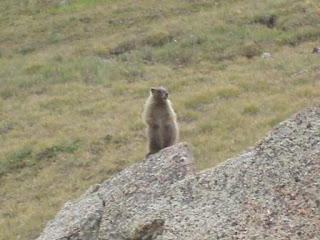 Marmots and Pikas and wildflowers oh my!
 On our way down, almost to treeline, nearing the end of our 12 mile hike. We made it back to our toasty tent early afternoon and took a nice long nap before we packed up and headed over to Handies Peak which was the next day's adventure.
 This was something we had to be careful of when crossing those snow fields. Some other Gunnison friends of ours were checking out an area like this above Gothic and the cave collapsed on one of the guys. His friends were able to rescue him but had to call reinforcements to winch him up hill in a litter, because he had some critical injuries. SO, be very very careful around these beautiful snow caves!
 Typically we work four ten hour days and have three day weekends to play, clean house, do homework, search for lost people, etc. The weekend of August 23rd we requested another day so that we could do something fun (out of town) before Brian started classes again. Therefore we decided to climb four fourteeners in the San Juan Range: Uncompahgre Peak, Redcloud Peak, Sunshine Peak, and Handies Peak. Here we start off with Uncompahgre Peak early morning as we broke away from treeline.
 Here's our goal, it was kind of a cylindrical shaped mountain, very different than those in the Sawatch Range. Uncompahgre is the sixth highest and stands at 14,309 feet. Uncompahgre means "hot water spring" and is named after a river.
 When we looked West toward Wetterhorn Peak (a fourteener)& Matterhorn Peak in the distance pictured two above. We heard what we thought might be ATVs buzzing around the Alpine Loop 4WD road. To our suprise we realized it was a huge flock of sheep! They were just munching away to their hearts content and "baaing" like crazy
.
 This is Redcloud Peak and Sunshine Peak in the distance as seen from the top of Uncompahgre. Redcloud is on the left and Sunshine to it's right. Our next day's adventure!

 Looking back down the drainage we hiked up. This area just south of Lake City is very colorful lots of old mining
.
 Brian and Toby taking in some incredible views from a sketchy lookout point. Although he grew up playing around the Mississippi River bluffs it's still a very very long way down
.


 This is on the way down we just passed a preserved area to my left. We were thinking it was for a butterfly study maybe? We saw so many in the area, but it's something we need to research. Back to the ole' Land Cruiser to take us to our next campsite at the Redcloud/Sunshine Trailhead!
 These pictures are all out of order, but OH well! This is our summit picture. We were sad to find that someone had stolen both the registry and the survey mark. So, it was just a stick in a pile of rocks. However, the views were amazing as always! Mt. Massive is 14,421 feet tall. The second highest peak in Colorado. The first ascent recorded (they had a registry) was in 1863 by Henry Gannett. There are actually several fourteen thousand something foot peaks connected to Mt. Massive. They are not considered a separate fourteener because they are less than the required distance from Mt. Massive. The hike is 13.75 miles round trip and has an elevation gain of 4,500 feet.
 These are the North Half Moon Lakes. There is another trailhead for Mt. Massive that comes up from the Southwest side called the N. Halfmoon Creek Trailhead, but it's super steep.
  Here's the "overcast" weather picture looking west toward the Elk Range, toward Crested Butte area. Needless to say, we did not stay on top for very long. It never did rain or lightning, thank goodness, but we headed back to camp to break down our tent and head over to Mt. Elbert.
 Saturday after work we drove up to the Mt. Massive Trailhead and hiked in for about 30 minutes where we found a semi-level spot to pitch our tent. It's always fun selecting a tent site at night.
 Sunday morning, I guess we could have stayed home and gone to church, but this is just as spiritually lifting! This is looking east toward Leadville.


 The day started off beautifully only a few puffy white clouds. We started late, around 6:50am. By the time we reached the saddle the clouds joined and the sky was mostly overcast. Hmmm....the big question to proceed or not?
 Day 2 of our EPIC "4 fourteener's in 3 days weekend". This is our first snow crossing on our way up to Redcloud Peak from the Silver Creek Trailhead where we camped. We woke up at 4:15am chowed down our bagels with cream cheese and reached the National Forest register around 5:00am. It was still very dark at this time so headlamps were essential. Being a little freaked out about bears, I made sure Toby had on his bell!
  The sun was just starting to hit the peaks opposite the drainage we were hiking up. It was a beautiful sunrise!
 Yes, I am a big dork.
 The last ascent up to Redcloud Peak. Not too bad, although it looks more like ski turns!
 Brian sitting at 14,034 feet signing us into the registry of Redcloud Peak! After signing our names he checked out the names of the folks that had peaked the day ahead of us. He discovered one of our friends from Gunnison, Mr. Evan Strauss and girlfriend had just hiked these two mountains 1 day ahead of us. CRAZY! we've never seen the names of anyone we knew on a registry before so that was really cool!
 We had gained 3,700 feet of elevation gain over a period of 4.5 miles. This is not where we stopped however, we were in for "bagging" as they say two fourteeners today! Toby, below, is looking over toward Sunshine Peak which is 1.5 miles South of us.
 Knowing we would be exposed above treeline for several hours we didn't stop for many pictures on the way over to Sunshine Peak. Redcloud is behind me to the right. We ate lunch on Sunshine at oh, 14,001 feet! Hmmm...Peanut butter and honey pitas!
 Marmots and Pikas and wildflowers oh my!
 On our way down, almost to treeline, nearing the end of our 12 mile hike. We made it back to our toasty tent early afternoon and took a nice long nap before we packed up and headed over to Handies Peak which was the next day's adventure.
 This was something we had to be careful of when crossing those snow fields. Some other Gunnison friends of ours were checking out an area like this above Gothic and the cave collapsed on one of the guys. His friends were able to rescue him but had to call reinforcements to winch him up hill in a litter, because he had some critical injuries. SO, be very very careful around these beautiful snow caves!


